Showing posts with label Fa'Ars River. Show all posts

Mar 19, 2013

Regions of the Valley (4) - Sildur Reaches

[This is the introduction to the region of the Sildur Reaches, a mapping and some hex details have been posted already].

The Sildur Reaches describes the region of the valley that lies north of the Great River, south of the Destriel Mountains, and between the Fa'Ars River on the eastern border, and the Greywater River on the western border.

The central terrain of this region is dominated by the patchy pine forests that together make up the massive Shadow Woods.  The pines of this region include the mighty Giant Cloudwood pine trees, that can reach as much as 400 feet tall, and as big around as 25-30 feet.  Some Cloudwoods are as old as 2,500 or 3,000 years, according to some Wood Elf sages that have been tending them as a life project.  Other pines in the area include the gnarleycone pine tree, the bristlecone pine tree and also the thinwhistle pine tree.

The whole region was once heavily, heavily forested, but it is believed that during the time of the Old Ones that it was deforested.  The reason is unknown, but occasionally massive fields full of the stumps of Cloudwood trees are still encountered.  These are often home to packs of dire wolves, giant badgers, and frequently swarms of giant burrowing insects (mostly giant beetles of different types, some as large as 10 or 12 feet long; and also a peculiar type of ground dwelling giant tick that are the bane of the dire wolves).

The name of the region, the Sildur Reaches, comes from the name of a Frost Giant warlord, or king as he preferred to be called, that ravaged the region during the time between the departure of the Old Ones and the arrival of the Westroners.  Some of the incredible crusading campaigns waged by the early bands of Westron knights in this region were against the armies of Frost Giants, and their ogre and bugbear allies.  Once the Giant Crusades were over, the Giants were confined to the mountainous lands to the north east, around the Tears of Heaven.

The road that extends from the city of Botts southwest to the city of Na Kram passes over the King's Highway.  Actually it passes under the King's Highway, but it does so through an area that is a flooded bog.  There is a vast tunnel through the mound of the Highway at this point, approximately 200 yards wide, and 30 yards high at the center, through which punt boat traffic frequently travels.  This boat traffic is one of the activities of the swamp town of Wall Morton.  This is a Westron town that is built all on pillars in the bog, and almost all movement in and around the town is by punt boat.  The swamp itself, called simply The Morton is about 75 miles wide, but this is spotted throughout with islands and high areas where trees grow, but the region is generally boggy and covered in fetid waterways.  A number of black dragons make their home here, and there is a order of Knights of the White Lady (paladins) who dwell in Wall Morton, and they patrol the region on the back of great hippogriffs.

Paladin of the White Lady fighting a Black Dragon for a captured maiden.

In addition to the swamp town of Wall Morton, there are a number of other independent towns, that are not part of either the Barony of Botts or of the Barony of Na Kram.  These are Willow (in the east, a river trading town on the Fa'Ars River), Gavaar and Roesen (two rival ports on the Great River), Jinette (trade town on the road between Na Kram and Huygen "The City of Lights" - which is across the Greywater River in the Darkearth Plains) and Haaksen (walled trade town on the road between Na Kram and Wall Morton).

Feb 17, 2013

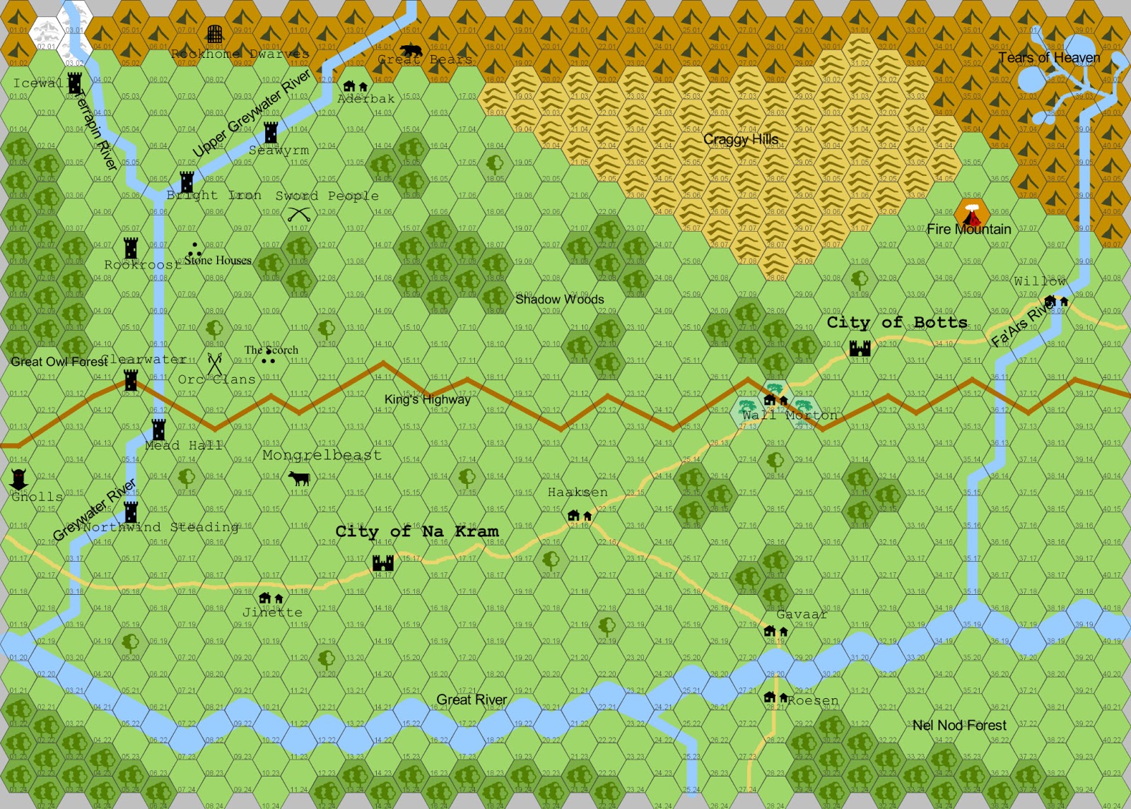
Sildur Reaches - Sandbox Map

[I have let this blog go mostly dormant, since September of 2012.  That was when I started teaching my first semester as a Professor at Columbus State University, and I have been busy.  However, I was working away on a number of different parts of the Valley of the Old Ones, although my current gaming interests take me in the directions of doing the next inter-river region of the world, the Sildur Reaches.  I am developing this in the manner of an Old School sandbox region, for players to explore and adventure in, without an over-riding plot or adventure theme.  The first step, of course, is a hexmap of the region . . .] 

So, here is the map of the Sildur Reaches, developed using Hexographer (a fantastic program, I highly recommend it).  Each hex on the map represents 25 miles across.  This is a region approximately 1000 miles wide, and about 600 miles from north to south.  My plans, for sandbox gaming, are to pick one or two areas, and then do a higher detail (smaller scale - probably 5 mile hexes, similar to the old Judges Guild village book hexmaps) treatment, showing lairs, adventure sites, dungeons, ruins, etc.


On the map can be seen the two main cities of the Sildur Reaches, Botts and Na Kram.  Also a number of other features.  In the western part of the Reaches, a lot of the details from the previous work on the Greywater Jarls is visible, including a number of the Steadings of the Jarls.  Here is a list of the main features, by hex number, of this map.

0115 - Furlingga Gnolls (tribal area) Home of a number of roaming tribes of Gnolls.

0303 - Steading of Icewall - Icewall is the name of the northern most of the River Jarl steadings.  It is the home of a very powerful clan of Storm King barbarians, the Isvater clan.  The current head of the clan is Kolfinn Haukson.  He is an old warrior, ruling his great clan, and his huscarls, with a firm but fair manner.  He has a daughter, Vigdis Kilfinndottr - who is young, lovely, and given to romantic adventures.  She has a group of friends, all young ladies, who attend her on all manner of adventures.

0508 - Steading of Rookroost - Rookroost is the name of the steading of the Daughters of the River Raven.  It was once an impressive castle, built high on a rocky abutment that rises some 200 feet above the surface of the Erantor river, which runs out of the Great Owl Forest, to join the Greywater River.  Today, the remains of the ancient castle are still standing, but the steading itself is built into the stone mound that it stands upon.

0512 - Steading of Clearwater - Near the point where the Greywater River passes under a great arch, to run beneath the King's Highway, there stands two fascinating structures. The first, of course is the tall, wide raised up artificial ridge that the King's Highway is built on.  As detailed elsewhere, this artificiality was built by the Old Ones, probably by Ba'a Zarn the Builder.  Up against this raised up ridgeline rises the small castle (steading) of Clearwater.

0516 - Northwind Steading - The furthest south of all the River Jarl Steadings, Northwind is further south than the King's Highway, almost half the distance between the King's Highway and the Great River.  Some way south along the river, is the great ferry crossing of the Greywater, marking the point where the road between the baronies of Huygen and Na Kram cross the Greywater river.

0612 - Steading of Mead Hall - There is a skald's song that starts out "Mead Hall, Mead Hall - Home of Heroes Brave and Tall!"  And it has, indeed, been a home for many heroes over the years.  If there is a Steading of Storm King barbarians that fits the stereotypes that Westroners believe in - it is definitely Mead Hall.

0706 - Steading of Bright Iron -The current Jarl of Bright Iron is called Garret Fingolsson.  His name is a curious one for a Storm King barbarian - since it includes a Westroner first name, but it was the name his father (Fingol the Just) gave him.

0708 - Stone Houses (ruins) - Immediately southeast of Bright Iron, just on the outskirts of the tended agricultural lands under the protection of Jarl Garret's fyrdmen, lay the lands of the Stone Houses.  The Stone Houses are curious round structures, long since out of use by their original inhuman builders, made of stacked stones.  The are similar to a Broch, or round house, that is built by some of the distant Storm King barbarians, however the roofs are all long since rotted off, and some of the stone walls are crumbling. What is curious about the structures, is that they are built for giant beings.  Larger than an ogre, whomever it was that first peopled these stone houses must have been of a great stature, perhaps 15 feet tall?  The typical stone house (as pictured below) has a first story that is partially underground, and then usually two more stories above that, and a peaked roof.  Sometimes the roofs are present (when they were made out of slate or other stone) and sometimes they are long gone (when they were made out of material that would have rotted with age, such as wood or thatch).  The typical structure is approximately 70 tall (at the peak of the roof), and about 80' across the base, at ground level.  Of course, there is variation, so some exist that are taller or shorter, and either bigger or smaller around.

0801 - Rockhome Dwarven Kingdom - Rockhome is a city built into a mountain's roots, it is the capital of a kingdom of Dwarves that exists largely underground.

0811 - Orc Clans (tribal area) - Home of a number of tribes of roaming Orcs.

1004 - Steading of Seawyrm - Seawyrm is the northern most steading of the River Jarls along the Upper Greywater River.  It is still a long way short of the edge of the Destriel Mountains, so the Upper Greywater is quite broad and wide by the time it reaches the shore where Seawyrm is constructed.

1011 - The Scorch - Southeast of Bright Iron, further south east even than the Stone Houses, there is a region along the border of the Orc Clan lands known as The Scorch.  This is a rolling plain, among some gentle swells of the land, where all life has been burnt off.  This was done during one of the wars between the Huscarls of Bright Iron and the Orc Clans.  It was meant as a reminder of the edge of the Orc Clan Lands that Bright Iron would tolerate. 

1018 - Town of Jinette - A walled independent town along the road between Na Kram and Huygens to the west. Population 4,250.

1107 - Sword People (tribal area) - These tribes of vicious and primitive savages are found mostly to the east, across the open plains between the Upper Greywater and the Shadow Woods.  These plains are known as the Blood Veldt.  The Sword People are a simple, bloodthirsty culture of savage barbarians that live in crude tribal groups (with simple shelters of sticks and skins that they erect), and make their basic economy by hunting the wooly rhinos of the Blood Veldt, and the herds of giant reindeer.  Occasionally, and all too frequently, they will have some sort of religious frenzy where the young warriors of the tribes will go on a blood frenzy, traveling in random directions, and slaying any and every living thing they come across, leaving the dead just to rot.  This is where the name Blood Veldt comes from...

1115 - Mongrelbeast Herds - East of Mead Hall, out across the Fields of Aton, between the Greywater River, and the Barony of Na Kram, roam the Mongrelbeast Herds.  These are herds of giant elk, as found in other regions of the valley north of the Great River, but the herds here have been affected by some foul strain of Old One magic.  A long time ago, a savage primitive people, similar to the Sword People north of the King's Highway in the same region, would wander and travel with the Giant Elk herds that have been trapped south of the King's Highway, since it was constructed.  These people, called the Elkmen, would wander with the herds, culling some now and again for food and skins, but mostly living with them in peace, and for protection.  The Elkmen had semi-domesticated some of the beasts to pull their great wheeled huts.  The king of the Elkmen lived in a massive giant wheeled hut called the Roaming House.

1303 - Village of Aderbak - Several days northeast of Seawyrm, towards the southernmost fingers of stony ridges coming down out of the Destriel Mountains, there is a curious village.  It is a small village made of stone buildings, and surrounded by a stout palisade, to aid in warding off the Sword People who venture that way.  The village's name is Aderbak, and it is known to be the home of both the Princess of Roses, and the thorny portal.

1417 - City of Na Kram - Baronial seat of the Na Kram Barony.  Home to the Dungeons of Borleos, a fearsome prison. Hol Kram, the Cathedral of Starry Wisdom, dedicated to Saint Gianna the Oracle, is located in Na Kram.  Population, 18,000.

1502 - Kingdom of the Great Bears - Home of a race of intelligent, magic using cave bears.

2116 - Town of Haaksen - Independent walled town at the crossroads on the road between Na Kram and Wall Morton. Population 4,800.  The Hospital of the Pierced Pelican is here - a religious hospital run by Sisters of the order of St. Brigid.


2812 - Town of Wall Morton - Independent town, with main buildings built on poles in the great Vinemorton Swamp, along the King's Highway. Population 5,200, although mostly outliers.

2819 - Town of Gavaar - Independent trading town on the northern bank of the Great River.  Home of the Corsairs of Iron, funded by the Shiaress of Gavaar. Population 4,700.

2821 - Town of Roesen - Independent trading and fishing town on the southern bank of the Great River.  Rival to the Shiaress of Gavaar, the Patriarch of Roesen funds the Ka'Bleez Marine - a small flotilla of patrol craft to protect trading ships from harassment by the Corsairs of Iron. Population 5,400.

3111 - City of Botts - Baronial seat of the Barony of Botts.  Home to the bardic college of Brandismore, and also to the Grand Lyceum of Abjurative Sorcery.  The Bardic College of  Brandismore is located at Feyd Hall.  The Lute Master of the Hall is Mistress Leanarra Gwayne.  The school of Abjuration is located in the heart of the city of Botts.  It is a walled campus of several buildings built upon a shining plaza made out of curious metals from a fallen asteroid. The head of the Lyceum is the Abjurer Glub Nar (male, human).  Tolbe Cathedral (the Orphans' Cathedral) is located here, and is dedicated to St. Lilliane.  Population, 17,500.

3507 - Fire Mountain - This curious volcano is riddled with layers and layers of caves and cavern complexes.  It is home to a number of dragons, amongst other fouler creatures.

3809 - Town of Willow - Walled riverbank town that runs a ferry crossing the Fa'Ars River. Population 4,400.



Jun 12, 2012

Posting update and Schedule

The eight Steadings of the River Jarls are still being posted.  The first five have been done, only three remain:  Clearwater, Mead Hall, and Northwind.  All three of these offer interesting setting descriptions, I think, and they each have an associated Adventure Location (which continues, and will finish, the Week of Adventure Locations).


In generating the Adventure Locations, references were made to locales, encounters, monsters and other elements.  These are planned to be detailed in the next week or two, so more content is on the way.

Further out, the three cities of Khomaes (home of the Diamond Villas, and the Glamor Hall for Bewitchment and Entrancement, and near the Purple Marsh), Werms (location of the Demesne of Planar Knowledge and Magical Petitioning), and Huygen (site of the wretched Black Prison of Volvedma) will need to be detailed with their own postings, and a little bit more about the other features of the Darkearth Plains (aside from what has already been done).  Then it is on to the next in the inter-river regions, between the Greywater and Fa'Ars River.  That area, the Sildur Reaches, includes the two cities of Botts (including the Bardic College of Brandismore, and the Grand Lyceum of Abjurative Sorcery) and Na Kram.  Also the Shadow Woods, Craggy Hills, Fire Mountain, and the curious Tears of Heaven (which is also Giant country).

Still working on the ValleyWiki idea...


Nov 20, 2010

The Nine Rivers

Within the Valley, which is some 3200 miles long from east to west, the most common way to distinguish regions is to consider the segments that are roughly split up by the Nine rivers that flow into the Great River.  These divide the Valley up into eleven different regions. 

The northern regions, west to east, are
  • The Shattered Plains
  • The Enchanted Forests
  • The Darkearth Plains
  • The Sildur Reaches
  • The Suuviz Region

The southern regions, from west to east are:
  • The region of Gateway
  • The region of Bartaloo
  • The Rising Land
  • The Wychwood region
  • The Nightside region
  • The Shale March

Four of these rivers flow from the Destriel mountains in the north, and each of them passes underneath the King's Highway.  Five of the rivers flow from the Holabria mountains in the south.  All nine empty their contents into the Great River, which continues to flow from the east to the west.

Listing the rivers, in order, from west to east we see that we have:
  1. Durwash River - which flows out of the Destriel Mountains, near the famous Groben Cave sites, down past one of the Altars of the Old Ones (the great stone amphitheater, near the King's Highway), flowing south into the Great River.  While the Durwash southwest from the Groben sites, there is a tributary that joins it from the north west, called the Stormwash. The region to the west of the Durwash is the Shattered Plains, and the region to the east is the Enchanted Forests.
  2. Pellet Water Run - This swift flowing body of water begins in the Holabria Mountains, with the glacial lake Sunshield as its point of origin.  It flows down, through the Burning hills, and finally north between the Falcon Woods and the Deeper Forest. The region to the west of the Pellet Water Run is the Gateway region, and to the east is the Bartaloo Region.
  3. The Two-Moon river is an amazing body of water.  First there is the magical property that the third moon of the world never reflects on the water, only the first and second moons (which is where the name comes from).  Second, the headwaters of the Two-Moon are high in the Holabria Mountains, and they are in fact a waterfall descending from a cloudy realm high over the Fircarran Peaks.  The waterfall splashes down and forms a lake called the Skybowl, and then begins the long journey down out of the mountains, north towards the Jazzan and into the Great River.  The Two-Moon river is joined also by the Tandalorn River, which originates to the east of the Skybowl, as a series of  springs.  The site of the Tandalorn Springs is where the Parn Tandalorn Monastary is located.  To the west of the Two-Moon river is the Bartaloo Region, and to the right is the Rising Land.
  4. The Lost Mare River is the next of the Nine.  It flows, at first mad and fast, south out of the Destriel Mountains towards Sorrad Forest, and then turning east, begins to lose a lot of its speed and anger, making its way lazily towards the King's Highway, and then on to the Great River.  Once it turns east away from the Sorrad Forest, one of the reasons for the great slowdown of the Lost Mare is because a lot of the river is diverted underground, feeding the mighty Underdark Sea, which is home to the Dark Elves and their so-called  "buccaneer kingdoms".  The Lost Mare is also joined by the Night Wash, a mountain stream fed tributary river.  The Lost Mare river divides the Enchanted Forests region to the west from the Darkearth Plains region to the east.
  5. The Fernrush River is next.  It empties out of Ancalhenn Lake, which is fed itself by four mountain rivers coming out of the Holabrian Mountains.  Several ruined Old One sites are along the Fernrush River, which for some forgotten reason was a focal point of Old One trade activity.  The Fernrush River divides the Rising Land to the west from the region of Wychwood to the east.
  6. The Greywater flows south out of the Destriel Mountains, joined by the Terrapin River.  There is a lot of river traffic along the Greywater from the many different Storm King tribes in the northern Shadow Woods.  Many different Storm King Jarls have holdings along the Greywater river.  The Greywater serves to divide the Darkearth Plains to the west from the Sildur Reaches to the east.
  7. The Tiazarr River is next.  Its source is in the south, in the Caves of Night.   The Tiazarr is joined by the Ceduria River, flowing out of Ceduria Lake, which is also home to Panakus River, one of the four feeding Ancalhenn Lake.  The Tiazarr River divides the Wychwood region to the west, from the Nightside region to the east.
  8. The Fa'Ars River flows past the great city of Narn, as it makes its way south from the Destriel mountains to feed the Great River.  The Fa'Ars has its source high in the Destriels, at a series of connected lakes known as the Tears of Heaven.  The region is widely avoided, as Giant country.  The Fa'Ars River divides the Sildur Reaches to the west of the river, from the Suuviz region to the east of the river.
  9. The Moa Thola is the last of the Nine.  It is a river that comes out of the Shale hills.  It is home to a large amount of Sun King tribal traffic.  The river itself is joined by the Errando River originating not too far from the Caves of Night.  Perhaps there is a connection to the Tiazarr River.  The Moa Thola river divides the Nightside region, to the west, from the Shale March region to the east.
Valley of the Old Ones - updated with Nine Rivers information - click for more detail